


Finding My Way to the World's Highest Lake: A Journey with the Tilicho Lake Trekking Map
Looking for the Tilicho Lake trekking map? This personal story follows a high-altitude journey to one of the world’s highest lakes. Discover the route, key stops, and emotional moments along a stunning trail through the Himalayas.
The first time I saw a photo of Tilicho Lake, I thought it wasnt real. The water looked bright blue, surrounded by snowy mountains, with a sky so clear it felt like a dream. I knew right thenI had to go there.
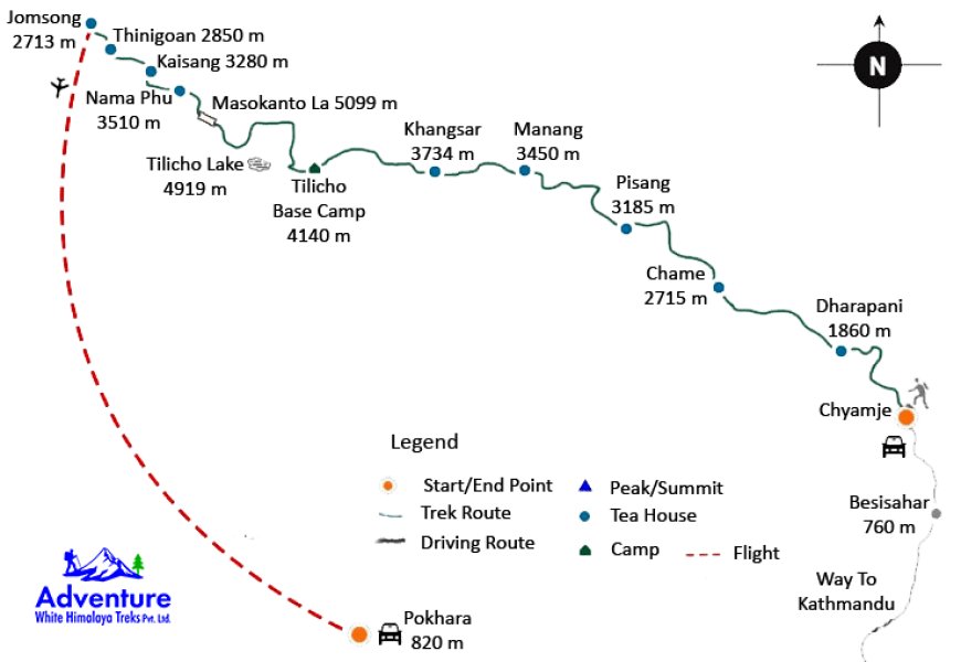
As I started planning, I kept looking at one thing again and again: the Tilicho Lake trekking map. It became my guide, my comfort, and my dream all at once.
This is my story of how I followed that map step by step, through beauty, challenge, and finally, deep peace.
Why Tilicho Lake?
Tilicho Lake is one of the highest lakes in the world. Sitting at 4,919 meters (16,138 feet), its hidden in the mountains of Nepal. You dont need to climb a peak to get there, but the trail still takes your breath awayin more ways than one.
We decided to include Tilicho Lake in our Annapurna Circuit trek. It added a few more days to our journey, but it added a lifetime of memories to our hearts.
Trekking Stats and Route Overview
If youre looking at the Tilicho Lake trekking map, heres what to expect:
-
Total Distance (round trip from Manang): About 36 km (22 miles)
-
Duration: 3 to 4 days (excluding the full Annapurna Circuit)
-
Highest Point: Tilicho Lake 4,919 meters (16,138 feet)
-
Main Stops:
-
Manang
-
Khangsar
-
Tilicho Base Camp
-
Tilicho Lake
-
From Manang, the trail splits off from the classic Annapurna Circuit and heads west toward the lake. Most maps show this clear turn, and it helped us feel safe knowing exactly where we were going.
Following the Map, Step by Step
We left Manang on a sunny morning. The map said the trail would be steep and rockyand it was. But it also showed waterfalls, rivers, and viewpoints, and those were real too.
As we walked, the map kept us focused. We stopped at Khangsar, a small village with prayer flags and old stone houses. From there, the trail became more rugged. The air was cooler, and the path narrower.
We reached Tilicho Base Camp by evening. At 4,150 meters, it was cold, and everyone moved a little slower. But the excitement was buildingwe were just one day away from the lake.
The Hardest and Best Day
The map showed a big climb the next morningabout 800 meters up to the lake. It was going to be hard.
We woke up before the sun. With headlamps on and hearts racing, we began the final push. The air was thin. The trail was steep. Every step felt heavy.
But then we saw it.
Tilicho Lake.
Blue. Still. Surrounded by silent mountains.
Everyone stood quietly. Some cried. Some smiled wide. I sat on a rock and stared.
I felt proud. Not because I reached the lake. But because I didnt give up.
Why the Map Matters
The Tilicho Lake trekking map wasnt just a paper to us. It was our path, our guide, our friend.
At high altitudes, trails can get confusing. The map helped us stay on the right track. It also helped us plan when to rest, where to stop, and how to prepare.
And more than anythingit made me feel brave. Every time I saw the trail line leading to the lake, I felt closer to a dream I once only saw in pictures.
Safety, Tips, and Emotions
If you're planning this trek, here are some tips:
-
Go slow Give your body time to adjust to the height.
-
Dress warm It gets very cold, especially near the lake.
-
Use a detailed map or GPS Dont just rely on signs.
-
Drink water It helps with altitude sickness.
-
Be kind to yourself Its okay to stop and rest.
One of my favorite memories was sitting beside a stranger at the lake. We didnt speak the same language, but we shared food and smiled. The mountains bring people together in a special way.
The Journey Back
After spending time at the lake, we walked back to Base Camp and slowly returned to join the main Annapurna trail. The trek wasnt over, but Tilicho had become the heart of our journey.
When I look back at the Tilicho Lake trekking map now, I see more than lines and names. I see moments. I see effort. I see joy.
Final Thoughts: Let the Map Lead You
If youve ever asked yourself whether you should trek to Tilicho Lake, let me say thisyes, you should.
Bring your map, your strength, and your sense of wonder. The trail is hard, but the lake is worth every step.
I followed that map with tired legs and a hopeful heart. And it led me to a place that will live in my memory forever.